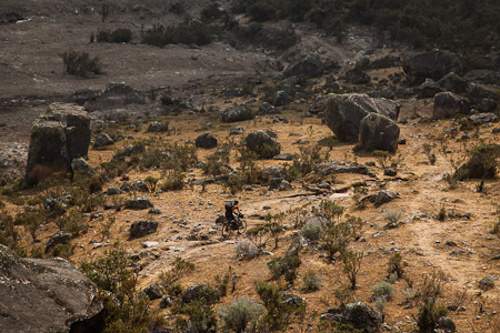
On the subject of Hike ‘n Bikes, I still need to catch up on the Laguna 69 ride from last week. Stunning vistas aside, it was a definitive success when it come to the all-important ratio between hiking (bad) and riding (good). Sometimes it’s a fine balance, with just a single wisp of sublime singletrack swinging it one way or the other.
I’m not sure that I can claim the same accolade for the follow-up adventure, the Santa Cruz trek – one of the most popular multi-day trails in the Cordillera Blanca. Although I”ll undoubtedly look back upon it with warmth – as memories of hardships soften – it was admittedly not the most satisfying of rides, at least when it comes down to ratios.
Nonetheless, the scenery was spectacular, and Charlie (head honcho of the Llanganuco Lodge) and I still managed to half the time that’s generally taken to trek the route – two days over the traditional and somewhat leisurely four.
Direction-wise, we chose to ride from Vaqueria (3850m) in the Paria Valley, to Cashapampa (2900m), taking advantage of a net elevation loss. Which way round is best is hard to say, as much of our anticipated descent from 4750m Punta Union had fallen prey to the vagaries of erosion, donkey hooves and poor trail maintenance. By which I mean it wasn’t really rideable.
Still, despite the excessive amounts of bike portaging, I can’t deny there’s a certain sense of twisted satisfaction in biking such hard-earned singletrack.
So with this in mind, here’s an account of riding the Santa Cruz trek. Repeat at your own risk…

But then again, it’s moments like these that make you question otherwise. And wish the trail would end.

Some 1000m of up, in total. Which is all very well, if the down, and down, and down, were halfway rideable…

Knowing the amount of altitude fluctuations that lay ahead, we packed as light as we could. Here’s Charlie’s rig – a carbon Scott Strike – with makeshift seatpack and handlebar bag.

And my slimmed down Surly Ogre, with Porcelain Rocket framebags, but minus rear rack. Riding the 29er in Ecuador and Peru has worked out well – I continue to be amazed by the capabilities of a rigid fork and big wheels over technical terrain.

As if slabby, rock-strewn hike ‘n bikes weren’t enough to contend with, a landslide in February had wreaked its havoc too. A tide of moraine had wiped out a great swathe of trail…

Yet despite all our cussing, it was hard to deny that when the views came, they might just have put it all in perspective.

Some gear talk: Charlie’s rechargeable toys. A Power Monkey solar panel provides juice for a Kindle/Blackberry/SteriPEN Freedom/iPod Shuffle and portable speaker. Not that you really need all these gadgets for a couple of nights under tarp… But it was fun to try them out.

Likewise, the mini-USB charged SteriPEN Freedom is definitely something I’ll be investing in. 48 seconds of UV blasting cleans half a litre of water.

Shoes, and leg warmers, a little worse for wear… Hiking up and down the rockspace in stiff-soled riding shoes was like walking in stilettos. Luckily I had my Vibram 5 Fingers with me too.
The Need to Know Bit:
We started at at lunchtime on day 1, and finished at about the same time on day 3, making it two full days of riding – give or take some time to take photos and chat to other hikers.
The trail on the Vaqueria side is in far better shape than that of Cashapampa, so perhaps the opposite direction would have been more fruitful.
There are some simply fantastic sections of singletrack when the grades are gentler. Unfortunately when the going gets steep, it’s mostly unrideable for mere mortals – largely due to poor trail maintenance and the excessing amount of mule traffic. The route would probably have been considerably more do-able on a bicycle a few years ago. Which makes me wonder if the lesser travelled treks might be a different story…
Interestingly, I noticed that Galaxia Expeditions in Huaraz run this as a 3 day tour, in the same direction we did it.
Not much to add, except don’t rush out and ride this route unless you have a particularly strange penchant for shouldering your bike, both up and down steep, loose and rocky grades…


I’m glad you did it so us virtual travellers got to enjoy those photographs – but it can’t have been so bad if you still had the energy to keep taking the camera out 😉
I think this is the next bit of kit you need if you are doing more of those trails:
http://www.kickstarter.com/projects/walnutstudiolo/bicycle-frame-handle
nice! Kickstarter is such a great idea.
I always have reserve energy for taking photos. (A bit like the space in my belly that’s always there for desserts).
Just AMAZING Cass. I don’t know what drives you to such extremes … (well. I think I do) Love of the out back, adventure, photography (superb as usual) and freedom from the mundane… but hey Cass… HARD work in spite of all that… stay safe above all and (no need to say) look forward to the next post. X
Hmmm…. I think on the whole maybe I’d have rather walked that one…. Impressed that you take the time to take SO MANY such high quality photos, I sort of get my head down and really don’t like to stop much for pics when I get going.
This is one that Joe would have called perverse fun.
I have some legwarmers for you, btw.
What an amazing trek! I don’t have the fortitude but am enjoying living vicariously through your photos.
This is one I’d have loved to be there for! Well, amongst pretty much all the others…
Thanks, as always, for sharing in your amazing style.
Scott
Thank you for this post! I’ve been dreaming going to Peru for a while.. You make the wait much more enticing! 😀
Cheers!
Ava.
Thanks of the comments!
A glutton for punishment, I’ll be trying out the Huayhuash Trek next…
This is an amazing entry among a long string of beautiful posts over the last few years. Inspiring and refreshing. I’m finally dialing my setup for getting out on my Surly- can’t wait!
Pingback: Bike ‘n Hike, not Hike ‘n Bike; Peru « while out riding
Hi Cass.
I just bikepacked the Santa Cruz from Vaqueria to Cashapampa (incl Alpamayo base camp). Contrary to your impressions, I found the downhill part almost completely rideable, except about half an hour of rock fields further down on the way out. Maybe the conditions have improved meanwhile… or maybe riding seriously technical single track on a rigid bike was just a bit too crazy? Anyway… its a great adventure… thanks for all your ideas.
http://www.mtb-news.de/forum/t/andix-von-kolumbien-nach-feuerland.697347/page-108#post-12175272
Huayhuash from Llamac to Cajatambo is due in a few days. If you could find that recorded GPX file of yours, I d appreciate a little email. Maps ony my Smartphone are excellent, but its always better to have a “real” track as well.
Thanks, Stefan.
Great to hear you had fun Stefan! Sounds like the conditions have improved, which I believe happens, depending on weather and donkey traffic. My riding buddy was also on a full suspension rig and is certainly not short of cojones – he had similar issues to me on the descent. Some lovely sections, but overall, not quite enough flow for me.
In any case, I found the Huayhuash a way more satisfying to ride, even if there’s a few sizeable hike ‘n bikes to deal with. I’m afraid I don’t have the gpx file to hand, but one should be easy enough to track down online. It’s a really popular hiking route. Good luck!