Here’s the third and final instalment of Hat’s Guatemalan & Honduran adventures.
After a few days duelling 18 wheelers on the coastal highway (which, somewhat optimistically, I call ‘contextual riding’ or ‘underbelly touring’), we were keen to swap the frenetic Honduran pavement for more tranquil dirt roads once more. We devised a loop for the last part of our ride, after pouring over our (somewhat inaccurate) IMTB Honduras map and digging through various guidebooks (the excellent Cycling Central America and the standard issue Lonely Planet – though I should add that Moon’s guide looks considerably better).
Our plan? To head out towards sleepy Trujillo, the oldest settlement in Honduras, via the Garifuna villages beyond Balfate. And then return to La Ceiba via Tocoa, Olanchito and a dirt track that flanks the beautiful Pico Bonito National Park – home to its namesake, a craggy 2435m peak.
Our original plan had been to ride south on a dirt road through La Union and Limones, in an effort to reach the capital, Tugulcicalpa, for Hat’s flight home. This coastal loop sounded more appealing though. Not only did it avoid an insalubrious stretch of road, known locally as ‘El Camino de la Muerte’ – the Highway of Death – for the frequent holdups between La Union and Salama, but it also left me a little closer to the Mosquito Coast, my next destination.

Dirt roads good. Dusty roads bad. Luckily traffic was light past the seaside hamlet of Balfate. Then it was just beach beach beach.

Idyllic surroundings: a fisherman, his homemade sail fashioned from plastic sheeting, glides his way upstream from the sea, waving enthusiastically as he passed under the bridge.

Hat pauses to sketch. Sadly, I've been banned from showing any on the blog...

There were numerable, clear water stream to cross...

... en route to the Garifuna fishing settlements of Rio Esteban and Rio Coco. Originally hailing from the island of San Vicente (before being forcibly deported to Roatan by the invading British), Garifunas now populate the coast from Belize to La Moskitia. Descendants of shipwrecked slaves and Black Carib Indians, their culture is a unique blend of South American and West African influences.

It was a quiet scene.

Sunset, and fishing boats were pulled up on the beach...

...as the day's catch was being prepared for the evening.

Tasty fresh fish.

Naturally cleansed with citrus fruit.

It didn't take long before we had a meal lined up at one of the houses that lined the deserted beach. Paula cooked us up a delicious plate of red snapper and fried plantanes, then her son, Marvin, lopped down a couple of coconuts for desert. We ended up camping in their yard, as the beach (which seemed peaceful enough) was deemed unsafe.

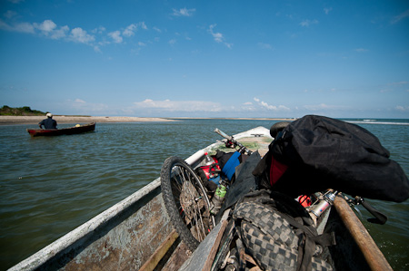
The following morning, we cycled on to Rio Coco, the last settlement along the coast. From there, we waited for a ride in a fishing boat to Betulia, the first point where the dirt track continued once more. Here's Hat loading up the bikes, while the fisherman chats on his cell phone. Apparently, reception is a little patchy round here...

After an hour's journey along a remote and rugged stretch of coastline, the boat turend down a shallow inlet just off Punta Betulia, gently grazing the sandy river bed.

From here, our the dirt road to Trujillo resumed once more, passing through the Garifuna villages of San Antonio and Santa Fe. Despite the guidebook warnings of robberies in the area, everyone seemed particularly welcoming and kind.

More fun crossing streams... (that double up nicely for washing buses)

And more wild, unkept beaches between Garifuna settlements, where boys played footaball and children paddled in the waters.

Trujillo is the country's oldest settlement, and was close to the site of Colombus's first landing in 1502. It's a veritable backwater compared to the likes of San Pedro Sula and La Ceiba, with a real frontier feel. Should you continue east past nearby Limon, the road soon peters out into beach and waterways, from where dugout canoes link remote dirt tracks into La Moskititia - the fabled Mosquito Coast.

La Bahia de Trujillo, where the kind folks at Casa Kiwi - a hostel closed for the season - offered us a plot of land to camp, cold beer and a hot shower.

The Pelican Patrol.

From Trujillo, we looped back towards La Ceiba. This is the road to Tocoa, normally frequented by overloaded trucks transporting palm oil.

A young palm plantation - African palm oil is an important Honduran export, and palm plantations occupy over 90 000 hectares in the area of Colon. There are currently several ongoing, often violent disputes between campesinos and the government over land rights. Anti-military graffiti had been sprayed across a couple of road signs.

Luckily for us, the bridge across one of the rivers had been washed out, funnelling truck traffic onto a dusty dirt secondary road. As ever, enterprising locals had set up a ferry service across the river for half a dollar a ride. Bikes were 25c. Bargain!

As we closed in on Sava, the road became busier and faster once more, plied by Dole fruit trucks headed for the deepwater port of Puerto Castilla. We'd have preferred more traffic like this - a bicycle pulling a trailer loaded high with plastic bottles for recycling.

It wasn't long before we turned off the highway. According to our insightful cycling guidebook, the ride from Olonchito back to La Ceiba passed through one of the most beautiful valleys in Central America. It certainly didn't disappoint, climbing ever upwards on a grassy dirt track, before finally whittling right down to a footpath and plummeting towards Yaruca on the other side.

It felt like we had the place to ourselves. Bliss. The track was too narrow for even the most insistent of jeeps - which is saying something, in this part of the world.

Elaborately woven, hammock-style birds nests hanging high in the treetops.

Sublime views from the descent to Yuruca, where we were put up by Americans setting up an orphanage. In the morning, we tucked into oranges plucked off the trees.

Quiet dirt roads... yay!

The jungle is rich in textures...

... and intricate shapes.

Plenty of enticingly clear pools at which to stop and swim.

Not only was this Hat's last day riding, but it was her birthday too. There seemed no better way to round off her journey then riding along the Rio Cangrejal. This beautiful river lead us right back into La Ceiba for her bus to Tegucigalpa, and her flight home to snowy Blighty...


A great read and fabulous photos as usua1. We’ve just come back to Samui after Christmas on Koh Tao free diving. We’re all coughing and feeling feverish with a nasty bug we picked up… a busy month ahead as we relocate to Chiang Mai… you DO have a wonderful life style… happy NEW YEAR!
I wish I knew how you find all these awesome roads Cass! Beautiful photographs. Have a great New Year Cass, many great miles ahead I hope.
These are some of the most stunning pictures I’ve ever seen of this area. Cass, you really have an eye for beauty and how it all weaves together in this amazing web of life. I’m in awe!