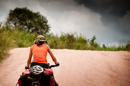
After running the gauntlet on the hectic, truck-infested highway to Bucaramanga, I was desperate to get back to the peace and quiet of the Colombian backcountry again – even if it promised an extra dose of rugged climbing, through the country’s already challenging Andean foothills.
Without doubt, Colombia is far more settled country than it was even a few years ago. But still, figuring out which routes both exist (rather than being a figment of the map’s imagination) and are safe (there are still small pockets of FARC, the ‘anti-imperialist’ revolutionary army) isn’t always straightforward. So tapping into local knowledge makes all the difference to finding good backcountry riding.
Luckily, I received no shortage of excellent help and advice from Pato at the Welcome Bucaramanga bike shop, and from young Alonso, at the biker’s hospitality network Warmshowers. Thanks too to Pato for lending me tools and a workstand, for some much needed Rohloff cable TLC on the Troll after all that mud. And for helping me get my BB7s running smooth and scratch-free. In terms of riding plans ahead, I’ve also been pointed me in other dirt road directions. Steve Tober, based in Ecuador, has reinforced the idea of hiking in the amazing Cocuy National Park, and tackling what seems like the gruelling but stunning Pasto-Mocoa road further south.
This last couple of weeks I’ve been enjoying the company of a British couple who used to live on a canal boat – always a dream of mine. Russell and Lorely also began their journey in Alaska, albeit a year later than me. Together we set out to ride the back way to Barichara and San Gil, via the mountain villages of Zapatoca, Galan and La Fuente.
The 153km route took us a few days. It proved to be one of the more challenging rides I’ve experienced in some time, yet also – as is so often the way – the most beautiful. It’s left me especially excited about Colombia’s dirt road touring potential ahead…
(additional route notes below, and within the captions)

Our backcountry ride started with a trip to the bakery in Giron, for a local pastry and a cup of invigorating Colombian coffee.

The venerable Bunuelo, a fried ball stuffed with cheese. Generally washed down with coffee, I spotted a local supping an early morning beer with his.

Within a few kilometres, we’d left both the pollution and the incessant noise of the main highway behind. I much prefer the quiet solitude of Colombia’s network of dirt tracks. The communities that are dotted around are more relaxed too.

This was pineapple country, with plenty of opportunities for natural refreshments en route. A cut and prepped pineapple set us back 1000 pesos, a little over 50c.

Smoke-friendly too: tobacco leaves drying by the roadside. This area is also know for its cigars.

Not much traffic on the road, just old Dodges and farm pickups, hauling payloads of pineapple and coffee.

After leaving Giron far behind, our road plummeted down to a bridge at the very bottom of a deep canyon, a lowly 400m in altitude. Then began a daunting 24km climb back up to Zapoteca, perched at a lofty 1700m. This area is known to be the amongst the hottest in Colombia. Timing our departure perfectly with the midday heat, we melted in temperatures close to 40c.

It was overwhelmingly, stiflingly hot. We struggled our way up, seeking refuge in occasional spots of shade. A crisp wind was gusting at this surreally parked car we’d spotted from far below. It was hard to move on…

Heading back up into the folds of the Andean foothills, the longest mountain range in the world. The riding in backcountry Colombia is said to be amongst the hardest in South America.

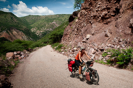
Most of the climb was on pavement, with steep switchbacks to contend with. The odd dirt stretch added to the challenge.

Colombian hills are peppered with roadside shrines – this one was protected by perspex and housed in an old truck tyre.

The views were epic – we could clearly see our descent to the river on the other side of the valley, and the long, looping climb back up again.

Zapatoca, home to a clutch of bakeries that filled our empty bellies, after an impromptu night camping just shy of town, when ambient light and our energy levels ran out.

Colombians love nothing more than chat. Our bikes caused quite a stir, and we were quizzed over their every detail. One of the locals insisted we take our steeds to his workshop and weigh them.

We were all worrying close to the 50kg mark… and I thought I was travelling light these days! Some of this is down to the winter gear I’ve been gathering for the high altitude months ahead.

Bear in mind too that Lorely weighs 52kg. We reckon her fully laden Surly Long Haul Trucker accounts for about 90 per cent of her body weight…

Then it was back to dirt, following a stunning, shaded track along the ridgetop.

The occasional back-of-beyond ‘cantina’ (a shack with a pool table, killer views and cold beer) offered a chance to break from the heat.

We kept to soft drinks though. Something of an acquired taste, these malt numbers hit the spot.

Then began a massive, rough and tumble descent back down into the belly of the valley.

Down, down, down. All that hard work the day before was paying off. For now at least.

Despite a prediction of rain, dry weather kept mud at bay too.

Incidentally, I’m enjoying riding the Troll. It’s handling these rough roads particularly well, especially considering it has close to 35kg of payload: no wallow in the frame, coupled with precise steering, makes for a confidence-inspiring steed.

Our eventual destination was a bridge that crossed the river, seen far off to the right. This was real up/down/up/down (and up) country, in the style of Mexico’s Sierra Madre.

La Fuente, still some way below…

Like most of the settlements around here, it was picture perfect, and completely bereft of any other tourists.

Our descent was broken only by a hiccup around a mountainous headland, following beautiful stone walls.

When we did eventually hit the river, down at 600m, it was hot and balmy. We camped for the night on a ledge by the Casa Comunal, offering great views across the valley and the thunderstorm sweeping through, Then it was straight back up again…

After climbing a mere 700m, we emerged in Barichara, touted as the most beautiful colonial village in Colombia.

Lorely, and the 90 percent of her bodyweight she pedalled up the hill.

And indeed it was idyllic. Best of all, it was without the expected sheen of an overly renovated tourist honeypot.

Barichara was established in the 18 century, and decreed a National Monument in 1978. It was easy to see why, with its maze of immaculate, multi-coloured streets draped across the steep hillside.

First stop in town? The bakery, of course. Alluring aromas wafted out of this doorway.

Another doorway. Perfect for nosy photographers.

Note colour co-ordinated bucket.

Fittingly, Barichara has a artistic, bohemian air.

Undoubtedly touristy at weekends, Barichara is quiet on weekdays, and real and lived in too.

Splashes of colour.

Each side street was a beautiful and proudly kept as the next.

I’d thought I was nearing picture-perfect colonial town saturation point. But Barichara had set a new standard.

We were lucky enough to meet Carlos, a local artist and mountain biker. Within a few moments he’d offered to put us up in his house, perched right up at the top of town (of course). Out of town for the night, he was more than happy to leave us a set of keys and let us kick back and relax.


Lots of lovely details, like this clothes hanging rack in the bathroom.

In the absence of old Ford F series trucks to photograph, I’ve spotted these colourful Daihatsus, suitably sized for the narrow, stone streets.

There were a few old Chevies too. We might have stepped back in time…

Always a sucker for American memorabilia.

Meet the frogspawn-like granadilla, a species of passionflower, and my current favourite fruit. Just a few hundred pesos each – about 25c.

This is one tasty treat I have yet to sample. Toasted, large bottomed ants, a specialty of the region. Could make a good addition to a trail mix…
The need to know section:
It’s about 153km from Bucaramanga to San Gil, via Zapatoca and Barichara, compared to around 95km on the main highway. The mix of paved and dirt roads are almost empty.
It can be broken up into two days’s riding, or three if you want to stay over in Barichara. Zapatoca, at about 70km, makes a dividing point – it’s 24km from the bridge, most of which are climbing. Then the next big climb is up to Barichara from the second big bridge. It’s a far easier climb, but best saved for day two. There’s plenty of rolling terrain in between, and altitudes range from 400-1700m.
Try and time your ascents to avoid midday – this place is seriously hot.
This area is both very friendly and safe. ´Es muy sano aqui,´ is an expression we often heard.


Great post and great photography! Looks like a fun time despite all the work.
Dan
The second great post this week with the usual high standard of photography… (what an amazing ride and I loved the organic details in the house you stayed in) What hospitality and generosity… What an amazing life you lead… hard work I know too well… but so rewarding! Take CARE in Columbia! X
Glad to hear its all going well, I heard on the news last week there was major flooding in parts of Columbia, good to hear you seem to have avoided it so far.
Gorgeous, gorgeous town! And I note with interest what you say about it being “more settled” than it used to be. I think S America is going through a fascinating period, throwing off the yoke of US imperialism – read Chomsky to see how the US has had its fingers in the S American pie for decades. The Bolivarian movement for unification of S America is exciting stuff.
It would be interesting to hear how the people in the streets view politics, especially as you travel through different countries.
brings back great memories – Barichara what a special place! and so glad to hear that it is still untainted by mass tourism and is a charming as it was 5 years ago.
I AM JEALOUS. Love the foto of the climb on the other side…definately epic! See you in Quito
Wow – those dirt roads look class, and the scenery is fantastic. I’m already missing the Andes so much – and your great photos aren’t helping!
take care and enjoy those big climbs…
Neil
Hey this is bringing back memories for me! Barichars seems the same as it was in 2007! I’m looking forward to more of your adventures along the windy backroads of Colombia, they were a lot of fun for me.
Okey… im dying of curiosity… how is the troll to ride in all the mud, sand and jungle? And how is it compare to the Sterling? Two good frames and you are testing them to the MAX! I just need to know ^_^ Keep up the great work, I check your blog everyday.
Thanks for the comments. For various reasons, I haven’t been able to update the blog for a while. I will get some more concrete thoughts on the Troll as soon as I can.
In brief though, I’ve been really happy with its handling and overall feel. It’s happier with heavier loads than the Thorn, but more fiddly with the Rohloff.
What a beautiful portrait of Colombia. Your photographs are like little perfect squares of beauty and bike-love. I need to come here more often.
Happy cycling-wishes from a Swede on a bike further south.
Incredible shots. I’ll have to make a stop here on my way through Colombia. 🙂
Wonderful photography -It shows the beautiful countryside.So delighted you found some companion travelers to enjoy the journey with.
Hi Cass – thanks to you, and Russ and Lorely, we decided to take this route from Bucaramanga. It was some of the best (and hardest!) riding we’ve done so far in our trip down from Vancouver. We loved it! Slowly but surely we’re becoming complete converts to back road cycle touring. Best of luck with the recovery.
Thanks for the comment, and really glad you enjoyed the ride! There’s loads of great backcountry touring in Colombia, if you don’t mind the odd hill…
Fantastic pictures!
Thanks. It’s a beautiful part of Colombia. All the charm of Villa de Leyva, but less of the crowds…
Hi Cass – another thanks for inspiring us to turn off the main road onto this route on our way through Santander. Well worth the sweat! In Zapatoca, we bumped into a reporter for the local radio station who wanted to interview us – and the first place he dragged us off to was the very same ferretería as you to weigh the bikes. The cheerful owner remembered you guys as the “gringos locos” who passed through a year and a half earlier! Oh, and our bikes were just as heavy if that’s any consolation…
Great to hear James. If you end up in Bogota, try and make it for Ciclovia on Sundays. That was another Colombian highlight.
Just arrived in Zapatoca. Epic climb with spectacular views! Well done for finding this route. Some locals tell me it’s the one of hardest or biggest in Colombia. Took me 4 or 5 hours from the river to Zapatoca with my heavily loaded beast. They tell me tour de France specialists do it in an hour and 15 mins. Not bad for 1500 metre change in elevation.
Glad you enjoyed it Nick. There’s a whole bunch of great stuff to come… You’ll probably be long gone by then, but I’m planning to be in Ecuador mid Dec.
Awesome. Going to take a break to sort some things out so may well overlap. Glad to hear your returning to South America!